

Agencies are using S&T-funded Mappedin to find their way quickly during critical incidents in schools and public buildings.
GPS systems may get first responders to incident scenes fast, but navigating buildings’ complex mazes of hallways and corridors in potentially chaotic or low-visibility situations can be tricky. Relying on hard copy or digital building blueprints can be cumbersome or even outdated, adding precious seconds when time is of the essence.
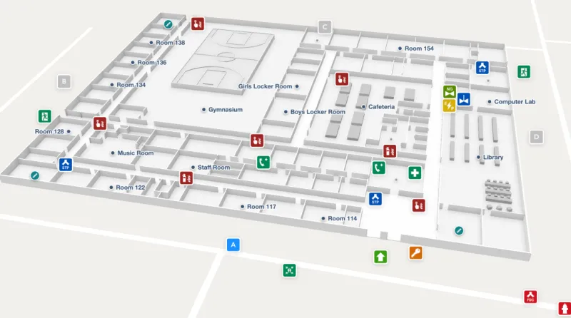
A solution, brought to you by the Science and Technology Directorate (S&T) and digital indoor map navigator Mappedin, was completed in 2022 and has since flourished. The online Mappedin mapmaking subscription, which can transform floor plans into interactive and easily maintainable digitized maps, was recently launched and is currently being used by both response agencies and corporate clients. With easy-to-use mapping tools and data, Mappedin provides high-quality 3D map creation, data maintenance, and map sharing to city executives, building owner operators and first responders to make and deliver maps for a variety of safety-related situations—from advance preparation and planning to assistance during emergency incidents.
“With Mappedin, first responders can quickly determine the interior layout of structures before entering a building to make informed decisions,” said Anthony Caracciolo, the S&T program manager who led this effort. “Mappedin assists them with identifying where interior rooms, doors, stairs, key equipment and hazardous materials are located and enables them to possess indoor awareness of a facility before entering.”
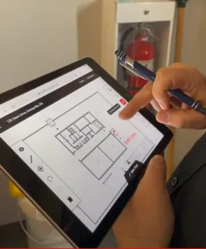
Mappedin provides intelligent digitization of floor plans from various sources (e.g., computer-aided design drawings, PDF documents, photographs) and maintains a digital reserve of 3D interactive maps accessible on tablets and cell phones. These maps can be marked up and shared via a private link accessible only to authorized personnel.
To save time in mapmaking, Mappedin leverages artificial intelligence (AI) to create high-quality 3D interactive indoor maps from uploaded floor plan images in 0.5 minutes to 3 minutes. The tool also uses LiDAR, a remote sensing method, to create floor plans from scratch. With an iPhone Pro or iPad Pro and the Mappedin iOS app, users can scan their indoor environment and turn the data into a digital map, which they can further edit and customize by labeling specific rooms and areas and adding attributes such as descriptions, photographs and links.
S&T initially funded Mappedin Inc. in 2019 to develop the indoor mapping tool (then called Response) after S&T's First Responder Resource Group indicated this type of technology was a top need. S&T’s goal was to help responders quickly navigate indoor floor plans in real-time when responding to incidents. Mappedin enables point-to-point wayfinding, like an indoor GPS, and is available to first responders and local governments as a licensed cloud-based service. S&T and Mappedin demonstrated the software in 2022, when first responders assessed the prototype’s efficiency and recommended improvements before commercialization. First responders found it better than existing technologies and liked its compatibility with many existing software platforms. Then, S&T and Mappedin further improved the software based on feedback from U.S. and Canadian first responders and local governments.
Public schools and fire departments are among users
Mappedin is already in use successfully. Since its official launch in September 2023, more than 4,000 user accounts have been created.
Many of Mappedin’s new customers are public schools and fire departments for whom mapping services are free. To provide life-saving technology to schools and first responders, two former firefighters have integrated Mappedin maps into their school safety product, AIKI ClassroomSAFE. The app provides situational awareness and a comprehensive view of other responding agencies, students, and the real-time status of classrooms. According to experienced firefighter and AIKI co-founder, Damian McKeon, Mappedin has taken a multi-hour mapping process down to a couple of minutes.
Some forward-thinking schools in the U.S. and Canada are also looking to use Mappedin. Three pilot Canadian cities – Orangeville, Kitchener and Waterloo–have already adopted the tool to digitize paper floor plans for a variety of building types for pre-planning and educational purposes.
Also, first responders in 911 incident dispatch will be able to access Mappedin-created maps within their safety platform for precise geolocation. By providing Mappedin’s accurate geo-located annotations of key safety equipment before the trucks arrive on scene, the 911 dispatch can be prioritized as the first point of contact. According to Dain Bolling, Founder of Pure Wireless LLC, Mappedin easily creates spatially accurate maps suitable for first responders during critical incidents.
Moreover, efforts are underway to map an entire Florida county. Mappedin is accelerating its Maps for Good initiative to address the needs of schools and first responders. Eligible participants will receive no- to low-cost indoor mapping. “Indoor maps are crucial for situational awareness in built environments, and Mappedin is proud to be part of the solution,” said Hongwei Liu, co-founder and CEO at Mappedin. “With Maps for Good, we’re putting AI-powered indoor mapping directly into the hands of front-line professionals, giving them purpose-built tools to do their jobs and keep people safe.”
Mappedin could be integrated with other tools
The Mappedin free subscription is available for schools and responders, where anyone is encouraged to create their own maps. The paid Plus subscription, released in February 2024, and the Pro subscription, coming later this year, add advanced capabilities, including integration with other tools.
“One such possible integration is with the S&T-developed gunshot detection system that detects and alerts police of gunshots,” said Caracciolo. “If integrated with Mappedin, police would not only be alerted of the gunshots, but they could also receive an interior map of a building depicting where the gunshots are occurring, thus enabling police officers to engage the shooter and locate and start treating victims as soon as possible.”
Additionally, corporate customers, such as airports, stadiums, and office buildings are also using Mappedin for things like complex mapping, wayfinding, and custom integrations.
“Ultimately,” Caracciolo added, “S&T invested in Mappedin to equip first responders with the best tool to pre-plan and navigate building interiors in emergencies.”
Learn more about S&T’s innovative industry partnerships and support for the nation’s first responders. For related media inquiries, contact STMedia@hq.dhs.gov.