


Sustained rains and flooding in California, tornado outbreaks in the Midwest and southern states, wildfires across several U.S. regions—the first half of the year has been a wild ride for weather. These events, which we tend to classify into “disaster seasons,” are now increasing in frequency and straining our communities, emergency responders, and our resources. And here we are today, June 1, at the start of the Atlantic hurricane season, fully aware of the devastating impacts and lingering consequences that these natural disasters can inflict.
The Science and Technology Directorate (S&T) is working to address some of the challenges agencies face in preparing for both short-duration events and prolonged, slow-moving disasters, which can last weeks or potentially months. We are also providing tools to bolster response efforts when, during an event or in the aftermath, these same agencies are bombarded with a continuous flow of information and need to quickly process, synthesize, and prioritize large amounts of actionable data.
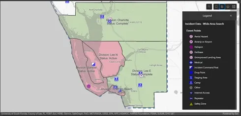
One tool, developed with the National Alliance for Public Safety GIS (NAPSG) Foundation, is ensuring that search and rescue teams are better prepared to face these challenges with the aid of flexible, cutting-edge applications. The Search and Rescue Common Operating Platform (SARCOP) is an interagency dashboard designed to assist agency leadership with planning and conducting more effective and efficient operations. SARCOP aggregates access to easy-to-use mobile applications (that work online and offline), web-based applications, and advanced geospatial analytics into a single platform. It is used for mapping out where search and rescue operations have occurred, and it provides detailed search coverage analysis so that no one is left behind.
During Hurricane Ian last fall, SARCOP was used by local and federal urban search and rescue (US&R) teams to plan and prioritize search operations, as well as document more than 85,000 damage observations, 24,000 human interactions, and 22,000 miles of tracklogs. So far in 2023, SARCOP has been used in over 20 incidents by federal, state, local, territorial and tribal teams across the country.
S&T and NAPSG continue to evolve SARCOP with input from the first responder community, after-action items and enhancement requests, and technology upgrades. We are working with the National Search and Rescue Geospatial Coordination Group and its 700 search and rescue subject matter experts to vet the existing functionality within SARCOP and provide a roadmap for future development.
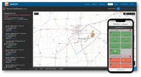
Today also marks the start of the annual SARCOP National Asynchronous Exercise, an opportunity for teams to try out new features, test the tools in their own environments, and ultimately be better prepared for the hurricane season and other potential hazard events. US&R teams from all levels of government will receive refresher training (including videos and documentation) and will participate in field data collection tasks and SARCOP navigation. The exercise, which runs through July 12, is US&R position-specific and aims to reduce the need for on-the-spot training during incidents. It is also a stress test for the system; feedback from the US&R community is vital to ensuring S&T and NAPSG continue to improve the readiness of all first responders in the field and the resiliency of our communities. Lessons learned will be shared during an after-action meeting soon after the close of the exercise.
Just days ago, our colleagues at the National Oceanic and Atmospheric Administration forecasted that the 2023 hurricane season will, fingers crossed, be ‘near-normal,’ with 12 to 17 named storms predicted. We’re committed to arming responders with the science and technology they need to also make it one of the safest.
Learn more about S&T’s Community & Infrastructure Resilience Program and our research and development efforts to optimize disaster response, mitigation and recovery operations.