

 Getting to your destination has never been easier, thanks to a number of popular global positioning systems (GPS) -based navigation apps available for download on smart devices. In fact, using these apps has become second nature to many drivers; according to the website The Pew Research Center, 67% of smartphone owners use their phone at least occasionally for turn-by-turn navigation while driving, with 31% saying that they do this “frequently.” The apps can be a life saver when you are stuck in traffic and desperately need to identify a new route. But what if you’re a first responder—an actual life saver—and you need to get to an emergency scene the fastest way possible, and possibly in an oversize vehicle?
For first responders, there can be drawbacks to using the same apps and following the same routes as everyone else. The apps may not take into account specific factors that can delay response time, like weather events, traffic accidents, or the size and weight of their vehicles. They also do not take into account local roadway or speed limit rules for emergency vehicles. When every second counts getting to an emergency scene, good enough just won’t cut it. That’s why the Department of Homeland Security Science and Technology Directorate (S&T) and partner Azimuth1, LLC are developing a solution, an app called QuickRoute.
Customizing navigation to meet responders’ need for speed
First responders, like the rest of us, use navigation apps because they are easy, the maps are updated frequently, and they provide critical details about our commutes—destination distance, arrival time, and a glimpse of what’s to come on the road ahead.
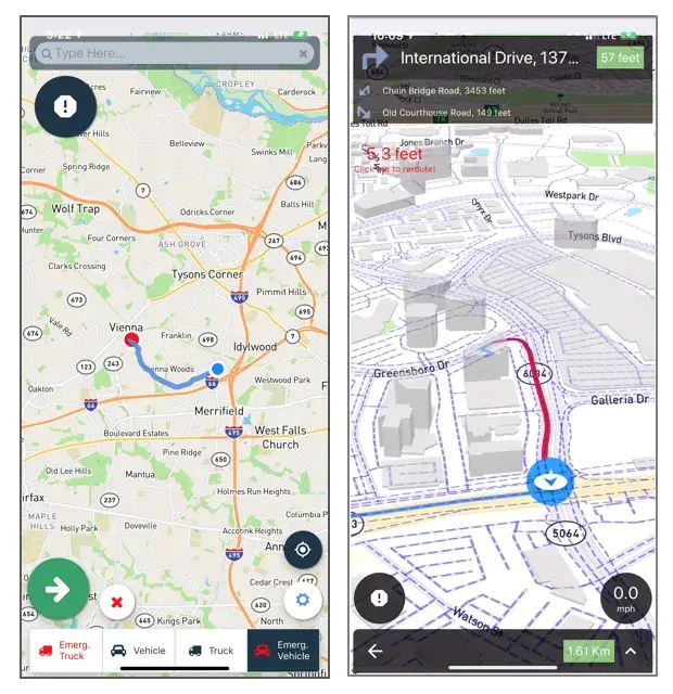
Like commercially-available apps, QuickRoute uses GPS and routing data to provide turn-by-turn directions, and it features an alerting mechanism to warn responders of hazards along the route, such as a flooded road, an accident, or downed power lines. But then the QuickRoute app takes navigation to the next level, leveraging additional data streams that civilian commuters aren’t privy to that will offer responders greater flexibility when time is of the essence.
 “If you have firefighters who have been called to an emergency, and they’re driving, say, a hook and ladder truck—perhaps they can’t traverse a narrow lane,” said S&T program manager Kimberli Jones-Holt. “QuickRoute will provide an alternate route to be able to get them to that emergency much more quickly than a traditional commercial application would.”
QuickRoute takes into account the type of vehicle being driven—whether a fire truck, or ambulances, police cruisers, incident command units, even standard sedans—as well agency roadway protocols, specs like turn radius or bridge and tunnel clearance, and their unique ability to use lights and sirens to clear paths and avoid signals. Other data sources, including weather patterns, traffic and transit schedules, and local jurisdiction rules (i.e., right-of-way, private access roads, ability to exceed posted speed limits, highway exiting) are also factored in, giving responders the quickest and safest route to the scene.
“There’s a tremendous need for an application like QuickRoute,” said Justin Green, Battalion Chief, Special Operations with Loudoun County (Virginia) Fire and Rescue. “It sounds very simple to go from point A to point B, but there are many factors that impact a first responder’s route. What we’re focusing on here is a lot of that information that we don’t have ready access to, such as traffic conditions, roadwork projects, weather impacts such as flooding or snow, or accidents that other agencies may report that we don’t hear about.”
Recent operational field assessment generates critical responder feedback
In April 2019, S&T and Azimuth1 field-tested QuickRoute with first responders and transportation stakeholders at a DHS federal law enforcement training facility in Maryland. The test plan, designed by S&T’s National Urban Security Technology Laboratory, had participants evaluate QuickRoute in several staged response scenarios, including medical emergencies, accident response, and fire calls, with hazards, weather events and roadway challenges placed along the routes.
“We designed this field assessment to obtain user feedback on QuickRoute’s capabilities, usability, and effectiveness,” said NUSTL Test Director Karin Decker, who led the day-long event. “Getting the technology into the hands of responders in a realistic setting allows them to really experience using it how they would commuting to an actual response. In doing so, they can identify areas for improvements that become apparent only in an operational setting.”
Responders were asked to use the app to navigate through simulated lane closures, drive the wrong way down a one way road, cross over road dividers and enter a roadway via an exit ramp. Along each route, the app sent alerts about road or weather conditions that could hamper a timely response and suggested alternate routes to more immediately direct their specific vehicles to the simulated emergency scenes. Responders evaluated QuickRoute’s effectiveness, ease-of-use, and compatibility with both iOS and Android mobile devices.
“Obviously the quicker we can get there, the better it is for everybody. This really has to do with our safety and the public’s safety,” said Battalion Chief Alan Butsch of the Montgomery County (Maryland) Fire and Rescue Service. “Anything that takes into account traffic congestion and routes us around that would make it safer for people that are sitting in the traffic. So, we wouldn’t have to use the shoulder and stuff like that. So, there’s a lot of benefits.”
Green agreed: “Most first responders are intimately familiar with the area they serve. But like anything in life, things change, and there have been numerous occasions where I found a road suddenly stopped, or I was impacted by a road project…or during weather events things change at a moment’s notice. QuickRoute would help with those unexpected conditions by aggregating all that information from those different data sources and have it readily available for our route selection.”
What’s coming down the road for QuickRoute
Feedback gained during technology assessments like this one is critical to S&T’s research and development efforts, given that the initial requirements for technologies like QuickRoute come directly from first responders themselves. Evaluators provided valuable feedback about additional app features, integration with computer-aided dispatch systems, and alerts and notifications that Azimuth1 will soon integrate.
The QuickRoute team continues to refine the app’s back-end system, which features after-action reporting functions that display paths taken and other key routing data that agencies can use to calculate time savings and advantages and disadvantages of particular routes. Responders will be able to compare routes calculated by QuickRoute with the normal routes that would be taken by civilians.
“This QuickRoute function is pretty nice because it allows agencies to study efficiencies that can be employed during future responses,” said Jones-Holt.
A report of the findings from the April 2019 QuickRoute operational field assessment will soon be posted to the S&T website, and the QuickRoute system itself—the app and a desktop version—will be available for purchase during the second quarter of 2020.
“Really having that head’s up alert that there’s hazards on the road, there’s potentially something that can slow down our response. We don’t really have that technology right now,” said Margaret Fowke, volunteer emergency medical technician with the Silver Spring (Maryland) Fire Department. “This app helps to move us in that direction. It will really help us in route, especially if we’re going to the hospital. We’ll already know that there are things in the way and what the alternate route is that we need to take—and that saves a lot of precious minutes and seconds, especially when you have a really critical patient.”
For more information about QuickRoute, please contact first.responder@hq.dhs.gov
Watch Video Now
Caption:
1. QuickRoute application map screenshot.
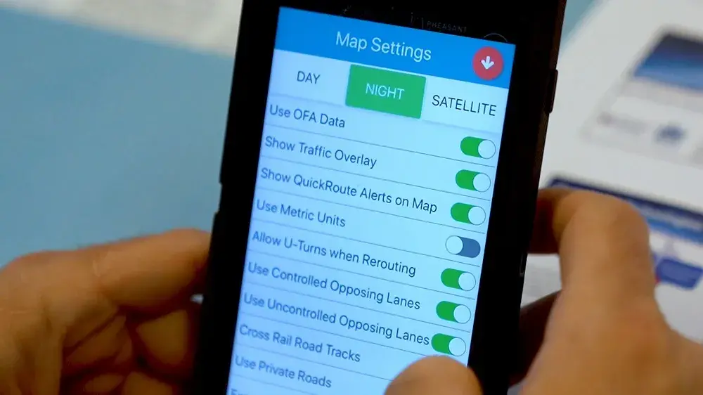
2. QuickRoute app map settings on a smart phone.