

As Hurricane Florence approached the United States East Coast this September and Hurricane Michael approached Florida, emergency managers and responders looked to predictive, situational awareness and decision support tools to help them prepare for the impending landfall and to respond once the storm arrived.
“When a hurricane is barreling ashore, it is too late to start thinking about disaster preparation. Several of the Department of Homeland Security (DHS) Science and Technology Directorate's (S&T) technologies, already in place in many communities, deployed with emergency managers, first responders, and decision makers to predict storm activity, provide alerts, support timely decisions, and keep communication lines open,” said William Bryan, Senior Official Performing the Duties of the Under Secretary for Science and Technology.
Helping with evacuations, search, rescue, and response, these tools are becoming a mainstay in many communities threatened by natural disasters. Since many of the tools are available for public use, they can help in the future as information about them becomes more widely known.
Predictive modeling for effective pre-positioning and response
To understand the storm surge and how communities would be impacted along the coast, many looked to the ADvanced CIRCulation (ADCIRC) tool, a high-resolution, high-precision storm surge/coastal flooding modeling software.
The U. S. Coast Guard (USCG) Research and Development Center provided ADCIRC data to inform Coast Guard entities during the storm. The National Oceanic and Atmospheric Administration, National Weather Service forecast offices, and North Carolina Division of Emergency Management also used ADCIRC modeling results to help guide storm response.
ADCIRC models helped the Fifth U.S. Coast Guard District make better decisions regarding evacuations and where to pre-position response assets.
“The ability to click on a spot on the Elizabeth River in downtown Portsmouth and definitively show on a graph that we weren’t looking at anywhere near historic storm surges was critical to my recommendation that we didn’t need to evacuate-and we didn’t. With the plethora of internet weather sites that people can choose to look at, having a data source that is recognized as a DHS Center of Excellence is critical to overcoming some of the hyperbole that is so readily available,” said Robert Hughes, an operations technical advisor with USCG Atlantic Area.
Visit the actual ADCIRC website for more information.
Similarly, the Simulation-Based Decision Support System for Water Infrastructural Safety (DSS WISE) LiteTM models a map of inundation scenarios caused by dam or levee failures by calculating the speed of surging water, the depths, and the size of land it would affect, all based on topography. With such a model, state and federal emergency managers can prepare emergency action plans.
Activity from the Carolinas intensified with the coming of Florence, and users were hurrying to run dam breach simulations to plan for possible evacuations where high-hazard dams were in danger of overflowing.
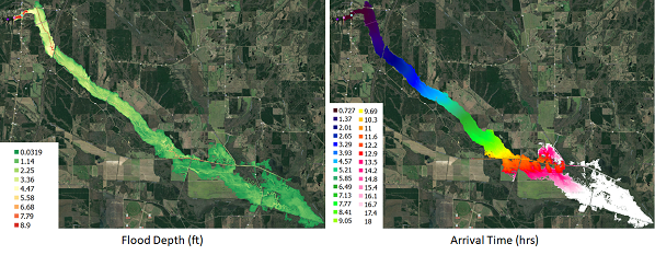
Dr. Mustafa Altinakar, Director of the National Center for Computational Hydroscience and Engineering at the University of Mississippi noted the center ran 157 simulations in relation with Hurricane Florence.
DSS-WISETM is available free of charge to state and federal users.
Providing layered data to emergency managers
In addition to using modeling for decision-making, emergency managers often need to understand many aspects of an emerging threat or disaster. Knowing where storm surge will occur, where the winds will be the strongest, and the rain the heaviest is critical for making the decision to evacuate. Emergency Mangers also want to know how certain the forecast is in terms of magnitude and timing and where the impacts will be relative to their respective community’s evacuation zones, demographics, and infrastructure. Understanding zone based impacts and expected evacuation times for each zone and scenario is critical in evacuation decisions. To make the right call, having all of this information in one place helps emergency managers make decisions more accurately and confidently. Having web based critical decision support capabilities enables anytime, anywhere availability with access from any device.
Before both hurricanes made landfall, emergency managers used S&T’s Web-Based HURREVAC to analyze the potential impacts of storm surge, wind, and inland flooding for the following two to five-day period.
Use of the tool surged during the week of Hurricane Florence’s approach to more than 1,000 concurrent active users and more than 800 during Hurricane Michael with account requests passing 5,100 emergency management stakeholders registered for Web-Based HURREVAC accounts since the provider opened early enrollment in June. One of the major improvements of the new system over the legacy system is the capability to merge and visualize modeled storm surge from NHC’s SLOSH storm surge products.
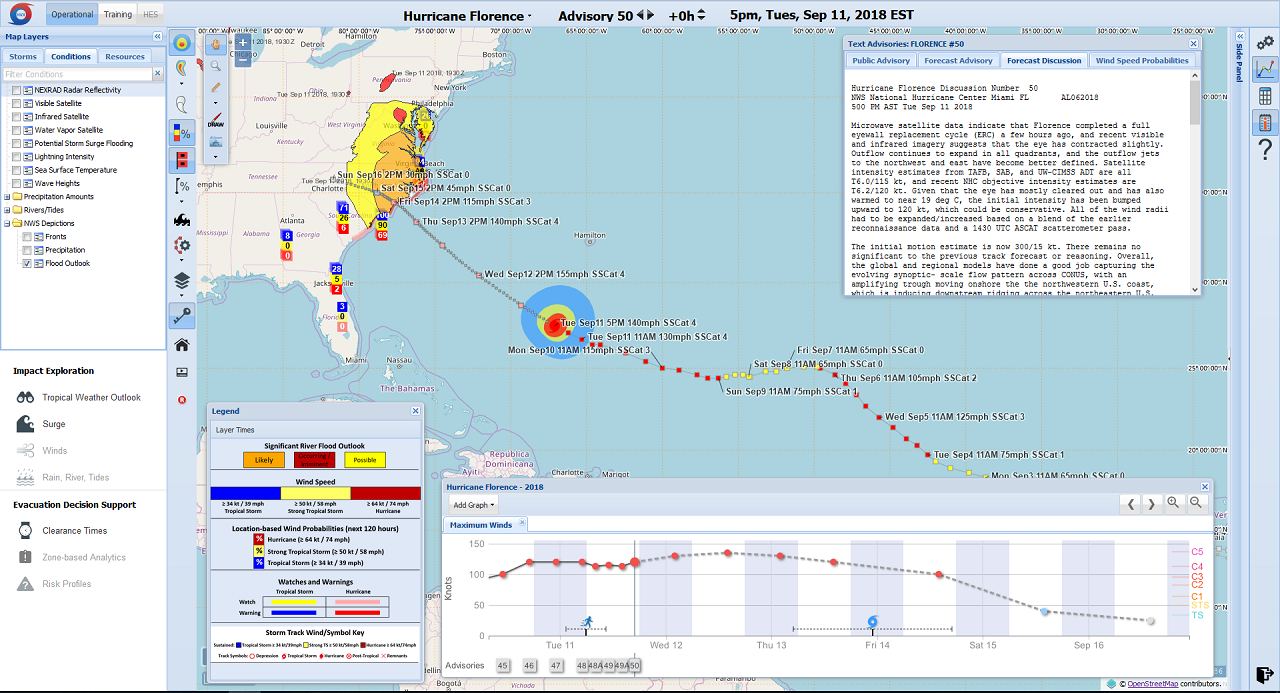
This hurricane evacuation planning system helps prevent “over” and “under” evacuations that can lead to dire consequences for those fleeing their homes.
“The United States Army Corps of Engineers leveraged new embedded training capabilities and held impromptu training sessions in advance of the storm so emergency mangers could more quickly and confidently access new features for increased situation awareness,” said S&T Program Manager Darren Wilson.
Users also monitored five other storms in addition to Hurricane Michael: Hurricane Leslie in the Central Atlantic, Tropical Storm Nadine off the coast of Africa, Tropical Storm Sergio in the East Pacific headed toward the Baja Peninsula of Mexico, Cyclone Title in the Bay of Bengal, and Cyclone Luban in the Arabian Sea
For more information, watch the Web-Based HURREVAC video.
Situation awareness for search and rescue
After a storm makes landfall, the situation changes constantly. Despite best efforts to predict and respond with the best data, real-time information becomes paramount in complex response scenarios where many jurisdictions and levels of government must work together.
S&T enabled a whole-of-government response to Hurricanes Florence and Michael by coordinating the use of a tactical situational awareness solution called the Team Awareness Kit (TAK) across response agencies from state, local, and federal offices including the Federal Emergency Management Administration (FEMA), U.S. Immigration and Customs Enforcement (ICE), U.S. Customs and Border Protection (CBP), Department of Defense (DoD), Department of Justice (DoJ) and Department of State (DoS).
S&T stood up a secured Hurricane Florence TAK server in the cloud which allowed 289 users from 40 organizations to share information using a TAK client app loaded on their mobile device (e.g. ATAK) or thru the web (i.e. WebTAK). Additionally, S&T connected the Hurricane Florence TAK server to existing TAK servers from nine organizations providing Hurricane Florence response, which enabled information sharing across a much larger set of response units to include DoD, DOJ, and DoS offices. Video feeds were also integrated into the Hurricane Florence TAK server by S&T from multiple aerial surveillance aircrafts providing real-time reconnaissance of flooded areas.
S&T also provided emerging technology for cost-effective, long lasting satellite tracking devices for FEMA’s search and rescue personnel so they could persistently provide their GPS position even where flooding had wiped out cell towers and power infrastructure, as is often the case in disasters. The satellite tracking device data feeds ingested into the Hurricane Florence TAK server enabled on-scene commanders to know exactly where their forward search teams were located. In the first five days of the Hurricane, rescue personnel were able to report their progress across more than 1770 miles using these devices.
The support from S&T enabled FEMA and other responders to exchange information across nearly 50 different organizations, allowing them all to share an operational picture with all the other response resources and activities in near real time.
Addressing persistent floodwaters
As the storm winds passed and the sun came out, the remaining floodwaters from the 24 to 40 inches of rain the storm dumped on the Southeast persist, posing a significant threat to communities.
As part of S&T’s larger effort to help flood-prone communities, the Flood Apex Program brought multiple resources to assist with the response to Hurricane Florence.
Prior to Hurricane Florence, S&T had deployed flood sensors to Charlotte, N.C. as part of an unrelated pilot project. During the hurricane, the sensors provided Charlotte public safety officials with additional information on flood conditions in the metro area. The program also leveraged its partnership with Pacific Northwest National Laboratory to simulate inland flooding as well as potential failure scenarios from several high-hazard dams.
Additionally, they helped inform incident management for businesses and critical infrastructure operators. Using the Single Automated Business Exchange for Reporting (SABER), an S&T-funded technology in use by FEMA, the program collected disruption information on businesses. This information was provided to government and public safety organizations.
S&T also provided building specific information about South Carolina buildings that were in high-risk flood areas, using satellite imagery, coupled with high performance computing and artificial intelligence.
As DHS continues to support its state and local partners with rescue operations after the hurricanes, the need to plan for community resilience has become increasingly important. New technologies, policies and strategies can help ensure communities and first responders are properly equipped for preparedness, response and recovery efforts in the face of hurricane season.
Captions
1. Dam-break flood maps for Mantee Lake Dam in Mississippi computed using DSS-WISE™ Lite show flood depth (left) and arrival time (right). By Dr. Mustafa Altinakar.
2. This HURREVAC map shows what weather-related situations the approaching Hurricane Florence can cause. Knowing where storm surge will occur, where the winds will be the strongest, and the rain the heaviest is critical for making the decision to evacuate.