

Learn How S&T Is Fighting Wildfire with Technology
Innovations that help make our communities safer and protect the people who serve them.
As the frequency of extreme weather events increases, more and more communities will potentially face the threat of devastating wildfire.
On average, 70,000 wildfires occur across the United States every year. These fires burn millions of acres of land; destroy homes, businesses, and infrastructure; and claim innocent lives. The long-term economic, environmental, and social impact of wildfires can be devastating.
The Department of Homeland Security (DHS) Science and Technology Directorate (S&T), along with the Federal Emergency Management Agency (FEMA) U.S. Fire Administration (USFA), state and local fire agencies, and industry partners, continues to develop new capabilities for first responders to combat this growing threat—and remain protected while doing so. Together with our partners, we are working to reduce the impacts of wildfires to our communities and safeguard those who serve them with advanced protective capabilities.
Wildfires across the U.S. and around the world are becoming more frequent, costly, and dangerous. Early detection of ignition increases the likelihood of timely containment and suppression of wildfires, saving lives and reducing property losses.
Wildfire sensors research focuses upon real-time and continuous identification of elements found in wildfire conditions, including particulate matter, volatile organic compounds, chemicals, and gases to detect ignition location, allowing for geographically targeted notifications and warnings.
S&T began efforts at developing wildfire sensors in late 2019 by researching literature from federal, state, and academic authorities to learn about wildfire characteristics. Available fire sensors at the time were optical cameras or thermal imaging—they would “see” the fires. But have you ever known there was a fire nearby, whether a campfire or a grill or brush, because you could smell the smoke before you saw flames? That’s what our sensors program is aiming to do—“sniff” out the fires as soon as they start, providing 24-hour sensing and alerting capabilities.
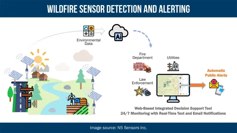
The wildfire sensor acts like a sensitive nose for gases and tiny solid particles in the air—these are signs of fire ignition. It “sniffs,” taking measurement data and sending it to the cloud every 18 seconds. A robust artificial intelligence (AI) enabled cloud-based system analyzes the data and compares it to the established baseline—wildfire sensors are “learning” sensors, they will gather data to establish a baseline for its location. After the analysis is complete, the system notifies the end user via a dashboard accessible on both desktop and smartphone. If a fire is detected, an alert is sent via text message and displayed in the dashboard. The addition of rapid, geographically targeted alerts, warnings, and notifications could prove the difference between a localized fire response and a large-scale tragedy.
While conducting research, S&T examined factors that included gas levels, humidity, environmental conditions, temperatures, and particulate levels. One of the deadliest aspects of fires are the different particulates that wildfires generate, with 2.5 parts per million (ppm) being the most common and deadliest, causing respiratory problems. These new sensors can detect gases and particulate levels that are about 1,000 times more sensitive than a home smoke alarm—while this is great for detection, it could also result in possible false positives, making the AI algorithms even more important to sensor wildfire detection.
S&T then modeled a historic wildfire to understand the level of concentrations of smoke composition, particulate matter, and dispersion at varying distances and wind conditions. This helped validate assumptions S&T had made from our research on how to best distribute sensors.
Sniffing for Wildfires
In 2021, S&T participated in an interagency test and demonstration of prototype sensors from multiple small business partners on about 1,000 acres in Northern California over two days. The sensors collected data and detected ignitions over time at a distance ranging from one to five miles.
In 2023, two small business partners deployed a total of 200 alpha wildfire sensors in various locations in the U.S. and Canada. One of the alpha sensors field-tested in Colorado identified a reignition at a controlled burn site and generated an alert that was passed along to the county office of emergency management. The alert gave the agency a significant 37-minute head start prior to the first 911 call, allowing for a much faster emergency response. Overall, the alpha sensors collected over 1,000,000 hours of data in the field, which was used to enhance the artificial intelligence (AI) learning algorithms now used in the updated beta sensors.
Throughout 2024, S&T and a small business partner, N5 Sensors Inc., in collaboration with the U.S. Fire Administration, will deploy approximately 200 beta wildfire sensors for operational test and evaluation with fire community stakeholders. Because they are “learning” sensors, they will gather data to establish a baseline for its location. The beta wildfire sensors will be able to notice unusual concentrations or spikes in particulates or carbon monoxide, that are unusual for the area based on its past data collection.
The new beta version wildfire sensors will also include:
- Improved ability to operate in areas with limited cellular connectivity, with enhanced alert and warning notifications;
- Reduced power consumption for longer run times between recharge cycles; and
- Integrated wind sensors that replace third party wind data, increasing accuracy of wildfire location prediction.
The inaugural beta deployment will be in Hawaii. Working with partners such as the Hawaiian fire chiefs and state and local officials, S&T plans on deploying 80 wildfire sensors and 16 wind sensors across the Hawaiian Islands. These sensors will collect data that can further refine how the final sensors perform, while also detecting anomalies that may indicate a fire. Through partnership with the Hawaii fire chiefs and stakeholders at the state and local levels, the team will test and evaluate the sensors in ways that will have national benefit beyond the shores of Hawaii.
Additional planned 2024 beta test locations include California, Colorado, Tennessee, Arizona, and Canada.
Alerting agencies to early ignitions is critical to successful emergency prevention, response, and recovery efforts, both for communities and public safety. A network of intelligent sensors allows first responders to get to the source of ignition sooner to suppress an initial blaze before it spreads out of control. Advanced notice of an imminent fire hazard could also grant time needed for communities to make life-saving evacuation decisions.
Through continued R&D in wildfire sensing capabilities, S&T and USFA aim to help communities detect and respond to wildfire emergencies more efficiently for a safer and more resilient homeland.
Wildfires present a significant threat to the United States, and S&T is fighting fire with technology. Wildfire sensor technology could provide the public with the advanced notice necessary to reduce the loss of life and property, while giving communities the information and time necessary to make life saving evacuation.
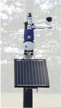
S&T has engaged in a novel research approach, as opposed to more traditional methods where sensors use optical (visible/near-infrared spectrum) to identify existing wildfires burning. The S&T sensors detect elements found in wildfire conditions, including particulate matter microns (PM2.5, PM5.0, and PM10) and environmental air quality conditions and gases (e.g., temperature, humidity, NOx, SOx, and O3). AI algorithms are used to compare ambient background conditions against wildfire elements to provide warnings if levels are elevated and alerts if spikes of concentrations are detected. Internal batteries are recharged through solar panel energy harvesting with LTE cellular network communications. A web portal and graphical user interface allow stakeholders to review sensor performance, download data, and receive text and email notifications for the warnings and alerts.
Learn More About Wildfire Sensors
- Wildfire Sensor Technology Fact Sheet
- Wildfire/Wildland Fire Sensors Report
- News Release: S&T Tests Next Generation Flood and Wildfire Alerting Technology
- Feature Article: Stoking Wildfire Resilience in Oregon
- Feature Article: S&T Wildfire Sensor Initiative Heats Up
- News Release: S&T Selects Performers for Phase II Wildland Fire Sensor Research
- News Release: S&T Successfully Evaluates Wildfire Sensors
Flooding After Wildfires
Large-scale wildfires dramatically alter both terrain and ground conditions. Normally, vegetation absorbs rainfall, reducing runoff. However, wildfires leave the ground charred, barren, and unable to absorb water, creating conditions ripe for flash flooding and mudflow. Deployable Internet of Things (IoT) technology monitors flood-prone areas in real time for rapid detection to alert officials, industry and citizens to potential threats and can enhance investments in flood mitigation.
Floods are the most common and costly natural hazard in the nation. Current flood costs for the 30-year period (1985-2015) are estimated at $8.2 billion in damages and more than 105 fatalities per year. Whether caused by heavy rain, thunderstorms, or winter storms, the results of flooding can be devastating. While some floods develop over time, flash floods—particularly common after wildfires—can occur within minutes after the onset of a rainstorm. Even areas that are not traditionally flood-prone are at risk, due to changes to the landscape caused by fire.
Flood risk remains significantly higher until vegetation is restored, which can take as long as 5 years after a wildfire. Flooding and flood damage after fire is often more severe, as debris and ash left from the fire can form mudflows. As rainwater moves across charred and barren ground, it can also pick up soil and sediment and carry it in a stream of floodwaters.
Through a Small Business Innovation Research (SBIR) award, S&T’s SCITI Labs program designed, developed, and tested a network of inexpensive, deployable flood inundation sensors. The sensors were part of a scalable wireless mesh network that rapidly measures rising water and can report flood conditions back to operations centers, first responders and citizens. This IoT technology was transitioned to the private sector marketplace. Today, IoT flood sensors are available commercially off-the-shelf as a low-cost solution for community resilience, as well as listed as an approved mitigation measure through FEMA’s Building Resilient Infrastructure and Communities (BRIC) grants program.
The Low-Cost IoT Flood Sensor SBIR spanned several years and saw more than 1,000 sensors deployed to numerous stakeholders for operational test and evaluation. The sensor pilots included state, county, city, federal, academia and not-for-profit participants in Virginia, Texas, Maryland, California, North Carolina, Kentucky, Tennessee, and New York. In addition, both the U.S. Army Corps of Engineers and U.S. Geological Survey deployed sensors in locations specific to their own engineering projects.
Early warning flood sensor technologies are allowing officials and citizens the time necessary to respond to fast moving flood events. These cost-effective and innovative technologies are helping to save lives and protect property. (DHS Video by Science & Technology Directorate/Released)
Wildland firefighters are exposed to many of the same naturally occurring respiratory hazards as structural firefighters. But unlike structural firefighters, wildland firefighters are unable to use standard self-contained breathing apparatus respirator systems, which are heavy, bulky, and limited to a short supply of air. Wildland firefighters need a small, lightweight device that is easy to put on and take off and can be relied upon to last during a lengthy response.
For many wildland firefighters, a cotton bandana is their standard and the resulting respiratory protection is woefully insufficient. Bandanas cannot protect against the extremely fine (and most hazardous) particles present in smoke aerosols from the wildland fire environment. As a result, wildland firefighters potentially inhale dangerous byproducts of thermal decomposition and combustion, including carbon monoxide (CO), acrolein, polycyclic aromatic hydrocarbons, aldehydes and ketones, and acid gases. Peak exposures of CO as high as 179 parts per million (ppm) have been measured in some controlled burns. The Occupational Safety and Health Administration’s permissible exposure limit for CO is only 35 ppm for an eight-hour exposure and 150 ppm for a 15-minute short-term exposure.
S&T is working to develop a respiratory protection system capable of removing airborne hazards present in the wildland firefighting operating environment. The Wildland Fire Respirator was most recently operationally field-tested by firefighters under high heat exercise conditions in the summer of 2023 in California. Results are forthcoming on the efficacy.
Learn More About Wildland Fire Respirators
- Wildland Firefighter Respirator Fact Sheet
- Wildland Firefighter Respirator Device Operational Field Assessment Report
- Feature Article: Field Testing a New Firefighter Respirator
- News Release: S&T Seeks Respiratory Protection Suitable for Wildland Firefighting
- Feature Article: Saving Lives and Breath on Wildland Fire Line
You may also be interested in:
Datacasting—Repurposing Unused Television Bandwidth
A paragraph might take only a few seconds to read, but when seconds could save a life, are words enough? In a crisis, a picture or video is worth a thousand words.
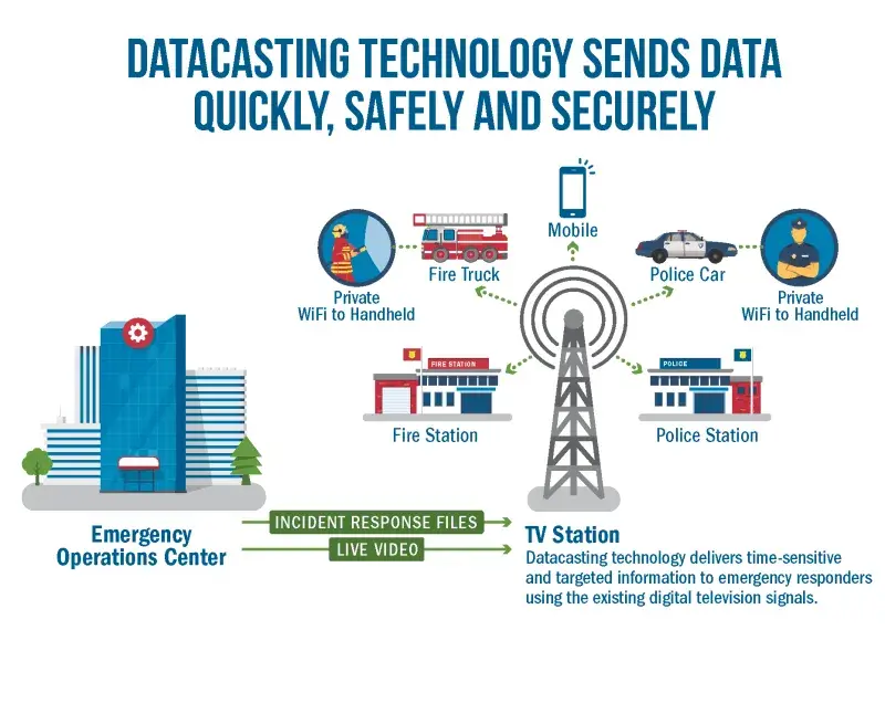
Sharing video and other data over existing public safety networks has been a challenge. Datacasting uses existing, unused broadcast television signals to deliver encrypted data, such as video to targeted recipients.
In an emergency, first responders need timely and relevant data to make informed decisions. Land Mobile Radio networks are intended for voice communication and do not have the capacity to transmit large amounts of data, including video. Commercial cellular networks can become overloaded or fail completely, as the network becomes saturated by public use. This leaves public safety agencies competing for the same network resources when trying to transmit their mission-critical information, especially video.
When broadcast television transitioned from analog to digital broadcast transmissions, it created the opportunity to allocate television spectrum in new ways, including delivering encrypted and targetable computer data. For example, an unlimited number of recipients can be targeted without running out of bandwidth. This not only reduces congestion on commercial cellular networks, but it complements existing systems. Further, it allows public safety agencies to transmit encrypted video and data that is invisible to the general public through the digital television signal.
S&T joined the Johns Hopkins University Applied Physics Lab and SpectraRep, their commercial partner, along with America’s Public Television Stations (APTS) and several Public Broadcasting Service (PBS) television stations around the country to implement pilot projects to determine the benefits and limitations of datacasting technology for public safety use.
The datacasting pilots took advantage of a portion of the public broadcasting station’s bandwidth for television programming. Public broadcasting networks are a unique television partner given their public service mission. Television programming uses a steady state of broadcast bandwidth during a non-emergency. Additional bandwidth can be allocated to first responders as necessary based on service level agreements for transmitting video, data files and other critical incident information (e.g., building blueprints and live security video) anywhere in the TV signal coverage area without relying on or overwhelming other communication channels.
In working with first responder agencies in Houston, Chicago, Salt Lake City, Boston, the state of Indiana, and others S&T conducted multiple pilots. The pilot activities included response to day-to-day activities, as well as large scale events such as disaster response. For example, in 2016, the Houston Fire Department used datacasting technology in response to catastrophic flooding to transmit helicopter video back to their command center to improve situational awareness for improved emergency response.
S&T continues to explore new opportunities for the application of this technology for public safety. A novel use of datacasting could extend the reach of Alerts, Warnings, and Notification (AWN). Public television stations can reach 97 percent of the U.S. population today—possibly providing an increase in overall AWN reliability and an additional pathway for AWN messages to reach the public at risk. While the datacasting infrastructure is maturing, research and development is necessary to support key use cases such as the application of datacasting in the wildland urban interface.
National Emergency Response Information System
S&T is supporting the U.S. Fire Administration (USFA) in the research and development of a new interoperable fire information and innovative analytics platform, known as the National Emergency Response Information System (NERIS).
This activity is made possible through a research and development contract awarded through S&T's Long-Range Broad Agency Announcement program. S&T is exploring the viability of novel concepts and innovative technical solutions to addressing the needs of the USFA. The work is addressing a shortfall between the current federal fire incident reporting and management system and the current needs of the country's fire and EMS community for real-time, actionable intelligence on local emergency incidents, as well as insights from regional and national data aggregation.
Fire is hot—over 1,000 degrees Fahrenheit hot.
Wildland firefighters often hike to remote and sometimes distant locations to respond to fires, while wearing heavy personal protective equipment. This challenge is compounded by the extreme heat and humidity that typically accompany the flames. As a result, heat stress is a major concern. From 1999 to 2009, California Department of Forestry and Fire Protection (CAL FIRE) data indicated the average number of heat stress injuries among wildland firefighters increased from 6.75 per year to 53.5 per year. In response, CAL FIRE requested S&T’s guidance in developing a new suite of garments to help reduce the number of heat stress injuries experienced by their wildland firefighters.
In partnership with the U.S. Army Natick Research, Development and Engineering Center National Protection Center (Natick), CAL FIRE, the U.S. Fire Service, and local California firefighters, S&T tested existing protective garments and established baseline data for enhanced solutions. S&T and Natick collected information about fire-resistant fabrics and chose materials based on manufacturer-supplied technical data. The materials were then tested and compared by an independent laboratory at North Carolina State University. Prototype garment systems were designed and manufactured to meet National Fire Protection Association 1977 and 1975 certification standards. System-level testing of the entire garment ensemble was conducted both in the laboratory and in wear test trials.
Approximately 1,000 prototype test garment ensembles were provided to participating wildland firefighting agencies for the 2012 and 2013 fire seasons. Operational personnel were asked to wear the prototype garment systems and compare the performance of the prototype garment systems to their current garment systems. S&T collected feedback from operational wildland firefighters at the conclusion of each fire season. This data was analyzed to determine how the prototype garment systems performed under operational conditions and whether they met firefighters’ needs.
The resulting Wildland Firefighter Advanced Personal Protection System improved radiant thermal protection, reduced heat stress, and improved upon garment form, fit, and function. The garments have been commercially available and in operational use by CAL FIRE since 2016.
Learn More About Firefighter Protective Garments
For more information about S&T's efforts to address wildfire challenges, contact first.responder@hq.dhs.gov.